The Most Remote Island on Earth – Glaciated Volcano • Uninhabited • Scientific Research
🇧🇻
⚡ Key Facts
🏛️
None (Uninhabited)
Capital
👥
0
Population
📐
49 km²
Area
💰
NOK
Currency
🗣️
Norwegian (Official)
Language
🌡️
Polar Maritime
Climate
01
🌏 Overview
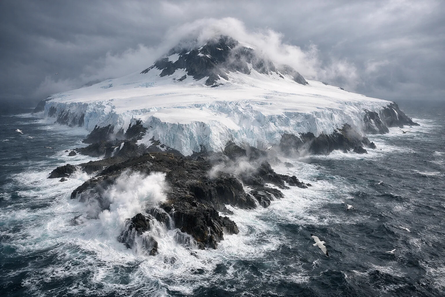
Rising from the storm-lashed waters of the Southern Ocean like a frozen fortress, Bouvet Island holds a singular distinction: it is the most remote island on Earth. Located 2,600 kilometers from the nearest land—the coast of Antarctica—and 2,500 kilometers from South Africa, this 49-square-kilometer Norwegian dependency exists in almost complete isolation, a glaciated volcanic cone where no human has ever permanently lived and fewer than 100 people have ever set foot.
Approximately 93% of the island lies beneath permanent ice, with glaciers calving directly into the sea from cliffs that can reach 500 meters in height. The central volcanic peak, Olavtoppen, rises to 780 meters through the ice cap, though the summit is usually shrouded in the clouds and fog that dominate this hostile environment. The surrounding waters are among the roughest on the planet, where the Antarctic Circumpolar Current drives massive swells and storms can last for weeks.
Despite its inhospitable nature, Bouvet Island has captured human imagination since its discovery in 1739. Today, an automated weather station transmits data to Norwegian meteorological services, and occasional scientific expeditions land on the narrow ice-free beach of Nyrøysa. For the vanishingly small number of humans who have experienced Bouvet firsthand, it represents Earth's last true wilderness: a place where nature remains absolutely supreme and human presence is merely temporary and fragile.
ℹ️ Important Information
Status: Bouvet Island is a Norwegian dependency with no permanent population. The island is a protected nature reserve, and all visits require permission from the Norwegian Polar Institute.
Access: There is no regular transportation to Bouvet Island. The only access is via expedition cruise ships (extremely rare) or chartered vessels, typically requiring 5-7 days sailing from Cape Town, South Africa. Landing is weather-dependent and often impossible.
Facilities: There are no facilities whatsoever—no harbor, no airstrip, no shelter, no freshwater source. Visitors must be entirely self-sufficient.
🔵 Realistic Expectations: Fewer than 100 people have ever set foot on Bouvet Island. This entry exists primarily for geographic completeness—the island is effectively unreachable for casual travelers. Information is provided for scientific and educational interest.
The World's Most Remote Island
Glaciers calve directly into the storm-lashed Southern Ocean as seabirds circle the volcanic peak
02
🏷️ Name & Identity
The island takes its name from French naval officer Jean-Baptiste Charles Bouvet de Lozier, who first sighted it on January 1, 1739, while commanding a French expedition searching for the mythical "Terra Australis." Bouvet reported seeing land through the fog, but his recorded position was significantly inaccurate, and the island would remain "lost" for nearly a century as subsequent expeditions failed to relocate it.
The Norwegian flag has flown over Bouvet since 1930, when the Dependency Act formally annexed the island to the Kingdom of Norway. Britain had briefly claimed it in 1825, but Norway's annexation went unchallenged. Today, the island is administered by the Norwegian Polar Institute and designated as a strict nature reserve.
Bouvet Island gained unexpected fame in 1979 when American Vela satellites detected a mysterious double flash in the South Atlantic near the island—the "Vela Incident"—which many believe was an undeclared nuclear test. The incident remains officially unexplained, adding Cold War intrigue to this remote place.
For the tiny number of visitors who have experienced Bouvet, there is no indigenous culture, no human history beyond scattered expeditions. Bouvet's identity is defined entirely by its isolation, its hostility to human presence, and its absolute wildness.
03
🗺️ Geography & Regions
Bouvet Island is a shield volcano rising from the South Atlantic seafloor at the junction of the Mid-Atlantic Ridge and a fracture zone. The island measures roughly 9.5 kilometers east to west and 7 kilometers north to south, with a total area of 49 square kilometers. Approximately 93% of this surface is covered by glacial ice, with the Wilhelm II Plateau dominating the interior. The highest point, Olavtoppen, reaches 780 meters.
The coastline consists almost entirely of steep cliffs—many over 400 meters high—where glaciers calve directly into the sea. The only significant low-lying area is Nyrøysa ("New Beach"), a lava platform on the western coast that emerged following a landslide between 1955 and 1958. This narrow stretch of ice-free ground is the only place where landing is even theoretically possible.
The island's volcanic origin is evident in the black basalt wherever ice doesn't cover the surface. The most recent eruption may have occurred as recently as 1955, and the volcano is considered potentially active. Geothermal activity has been detected, and warm ground exists in some areas.
Key geographic features include Cape Circoncision at the northern tip, Kapp Fie to the south, and Westwindstranda along the western shore. The surrounding waters plunge to depths exceeding 3,000 meters within just a few kilometers of the coast.
03b
🗺️ Map
04
📜 History
Jean-Baptiste Charles Bouvet de Lozier spotted the island on New Year's Day 1739 while commanding a French expedition. However, his recorded position was so inaccurate that subsequent expeditions—including James Cook's—failed to relocate it. For decades, the island's very existence was questioned.
British whaler James Lindsay made the first confirmed sighting in 1808. American sealer Benjamin Morrell claimed to land in 1822 (disputed), while the first verified landing came in 1825 when Captain George Norris raised the British flag. Norway's involvement began in 1927 when the research vessel Norvegia made the first scientific landing.
The mysterious "Vela Incident" of September 22, 1979, brought unexpected attention when US satellites detected a double flash consistent with a nuclear explosion near the island. While officially unexplained, most analysts believe it was a joint Israeli-South African nuclear test. The incident highlighted how even Earth's most remote places cannot escape geopolitics.
Since annexation by Norway in 1930, Bouvet has seen occasional scientific expeditions and amateur radio operations (among the rarest "entities" in ham radio). A manned weather station operated from 1977-1979. The island was designated a nature reserve in 1971, with expanded protections in 2020.
05
🐧 Wildlife
Bouvet Island's only permanent residents are its wildlife. Despite the harsh conditions, the island supports significant populations of Antarctic and sub-Antarctic species. Macaroni penguins dominate, with colonies numbering in the tens of thousands nesting on ice-free cliff ledges. Chinstrap penguins also breed here, making Bouvet one of their northernmost breeding grounds.
Antarctic fur seals haul out on Nyrøysa and other rocky shores, having recolonized after being hunted to near-extinction in the 19th century. Elephant seals occasionally appear, as do leopard seals hunting in the surrounding waters. The seas around Bouvet teem with life—krill swarms support fish populations that feed seabirds and marine mammals.
The island's birdlife extends beyond penguins. Antarctic petrels, snow petrels, Wilson's storm petrels, and black-browed albatrosses all nest or visit. Cape petrels wheel around the cliffs, and giant petrels scavenge along the shores. For ornithologists, Bouvet represents pristine habitat where seabird colonies exist without human disturbance.
Vegetation is almost non-existent—limited to mosses, lichens, and algae clinging to exposed rocks. The island lies below the tree line and receives too little sunlight during winter to support significant plant growth. This barren quality only emphasizes the remarkable adaptation of animals thriving at the edge of the habitable world.
🦭 Key Wildlife Species
Penguins:
Macaroni Penguin — largest colony
Chinstrap Penguin — breeding population
Marine Mammals:
Antarctic Fur Seal
Southern Elephant Seal (occasional)
Leopard Seal (visitor)
06
🍜 Cuisine
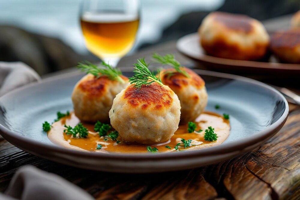
Polar Fiskeboller
Norwegian Fish Balls
The classic Norwegian fish balls—comfort food carried on every polar expedition, traditionally served in white sauce with potatoes, providing familiar taste of home at the edge of the world. This recipe serves two.
Ingredients: 400g white fish (cod or haddock), 2 tbsp potato starch, 100ml milk, 1 tsp salt, ¼ tsp nutmeg, ¼ tsp white pepper, 1 egg. For sauce: 2 tbsp butter, 2 tbsp flour, 400ml milk, Salt and white pepper, Fresh dill.
Preparation: Blend fish in food processor until smooth paste. Add potato starch, milk, salt, nutmeg, pepper, and egg. Blend until completely smooth and airy—this takes several minutes. Chill mixture 30 minutes. Bring large pot of salted water to gentle simmer. Use two spoons, shape mixture into oval balls about golf-ball sized. Poach in batches 8-10 minutes until they float and are cooked through. For sauce, melt butter, whisk in flour, cook 1 minute. Gradually add milk, whisking constantly until smooth and thickened. Season with salt and white pepper. Serve fish balls in sauce, garnished with dill, alongside boiled potatoes and carrots.
💡 Norwegian expedition crews say these taste like home—powerful medicine for isolation and homesickness.
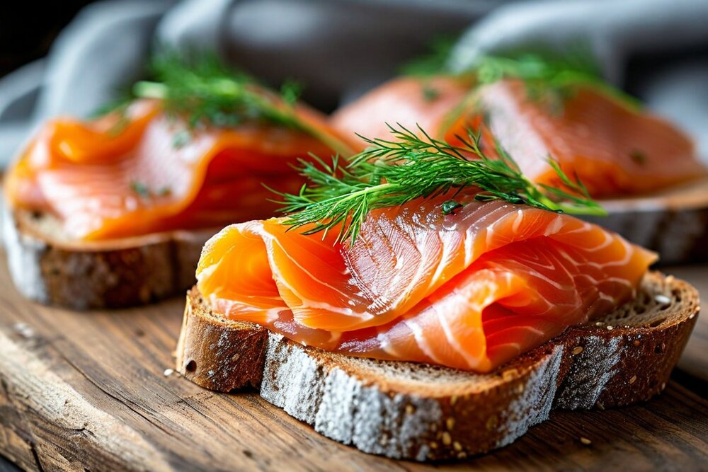
Smørbrød med Røkelaks
Smoked Salmon Open Sandwich
Silky smoked salmon on dense bread—the quintessential Norwegian expedition lunch, requiring no cooking and providing essential omega-3 fats crucial for polar conditions. This recipe serves two.
Ingredients: 4 slices dense rye bread, Butter, 150g smoked salmon, 2 tbsp sour cream or cream cheese, ½ lemon, Fresh dill, 1 small red onion, very thinly sliced, Capers, Black pepper.
Preparation: Butter bread generously—this is non-negotiable in Norwegian food culture. Spread thin layer of sour cream or cream cheese on each slice. Drape smoked salmon in loose folds over bread, covering surface. Top with onion rings, capers, and fresh dill. Squeeze lemon over, season with black pepper. Serve immediately. The combination of rich salmon, sharp onion, briny capers, and fresh dill creates perfect balance. On expeditions, this simple assembly transforms basic provisions into something that feeds the soul as much as the body.
💡 The best smørbrød are eaten with knife and fork, never picked up—this is elegant survival food.
Rømmegrøt
Norwegian Sour Cream Porridge
A traditional Norwegian celebration dish—thick, rich sour cream porridge that provides extraordinary calories for extreme cold, traditionally served at midsummer but beloved by polar crews year-round. This recipe serves two.
Preparation: Simmer sour cream in heavy pot 10 minutes, stirring frequently. Sift half the flour over, stir vigorously until butter begins separating out—this is supposed to happen. Remove the melted butter that pools on top, reserve it. Add remaining flour, stir until smooth. Gradually add milk, stirring constantly, until porridge reaches desired thickness—should be quite thick. Add sugar and salt. Simmer 10 minutes more, stirring. Serve in bowls, make well in center, pour reserved butter into well. Sprinkle generously with cinnamon-sugar. Eat from outside edges inward, dipping each spoonful in the butter pool.
💡 The separated butter is not a mistake—it's the best part. Save every drop.
07
🍷 Wine, Spirits & Drinking Culture
Bouvet Island has no wine production, no permanent inhabitants, and no drinking culture. The uninhabited Norwegian dependency in the South Atlantic — a glacier-covered volcanic island considered the most remote island on Earth (1,700 km from the nearest land, Antarctica) — is visited only by occasional scientific expeditions and amateur radio operators. Any beverages consumed here are brought by visitors.
08
🌡️ Climate
Bouvet Island experiences a severe polar maritime climate, characterized by persistent cloud cover, frequent precipitation, and howling winds. Average temperatures hover around 1°C year-round, with summer highs barely reaching 4°C and winter lows dropping to -4°C. Snow falls throughout the year, though most accumulates during the winter months (June-August in the Southern Hemisphere).
The island sits in the path of the "Roaring Forties" and "Furious Fifties"—the powerful westerly winds that circle the Southern Ocean. Gale-force winds are common, and hurricane-force storms occur regularly. These winds drive enormous waves that make landing extremely dangerous even in relatively calm conditions.
Fog and low cloud blanket the island for much of the year, often obscuring the summit entirely. Precipitation occurs on approximately 300 days annually, mostly as snow but sometimes as freezing rain. Sunshine is rare—the island receives less than 500 hours of sun per year, compared to over 2,000 hours in most temperate regions.
The only "favorable" season for visits is the Southern Hemisphere summer (December-February), when temperatures are slightly less brutal and daylight hours extend. Even then, successful landings depend entirely on brief windows of acceptable weather.
Earth's Most Isolated Outpost
Glaciers meet the Southern Ocean amid perpetual storms and sub-Antarctic wilderness
09
🔬 Expeditions & Research
Scientific interest in Bouvet Island stems from its isolation and pristine environment. Norwegian expeditions in 1927, 1928-29, 1971, and 1977-79 conducted geological, biological, and meteorological research. The 1977-79 expedition established a manned weather station that operated until evacuation became necessary.
Modern research focuses on seabird population dynamics, seal biology, glaciology, and volcanic monitoring. An automated weather station transmits data to Norwegian meteorological services, providing crucial information about Southern Ocean conditions. The island also hosts equipment for monitoring nuclear test ban treaty compliance—fitting given the Vela Incident.
Amateur radio operators prize Bouvet Island as one of the rarest "DXCC entities" in the world. Several DXpeditions have braved the journey to activate the island, most recently in 2023. These operations require massive logistical support and typically last only days before weather forces evacuation.
For adventurers, reaching Bouvet represents the ultimate achievement. A handful of private expeditions have succeeded, though the combination of extreme remoteness, brutal weather, and lack of safe anchorage makes success far from guaranteed. Most who attempt the journey must content themselves with sailing past at a safe distance.
10
✈️ Getting There
There is no scheduled transport to Bouvet Island. Reaching it requires chartering an ice-strengthened vessel, typically from Cape Town (≈2,500 km, 5–7 days at sea) or, more rarely, from Tristan da Cunha or the Falkland Islands. Norwegian Polar Institute permission is mandatory, and most successful landings have been by scientific or amateur-radio (DXpedition) parties using inflatable boats or, occasionally, helicopters operating from the deck of the support ship. Weather windows for landing on Nyrøysa beach are measured in hours, not days, and many expeditions are forced to turn back without setting foot ashore.
11
📋 Practical Info
Visa: no visa exists; entry is governed by a Norwegian Polar Institute permit issued only for science, conservation or sanctioned expeditions. Health: no facilities — every expedition must carry a doctor and full medical kit. Safety: extreme. Hazards include calving glaciers, hypothermia, hurricane-force winds, leopard seal attacks in the water, and the absence of any rescue infrastructure. Communication: Iridium satellite phones only; there is no cellular coverage and no permanent radio station. Currency: Norwegian krone (NOK), though there is nothing to spend it on.
12
💰 Cost of Living
Bouvet Island has no economy, no shops, no services and no permanent residents, so a conventional cost-of-living index is meaningless. The relevant cost is that of mounting an expedition: chartering a suitable polar vessel runs €15,000–€40,000 per day, and a successful 30-day expedition from Cape Town typically costs €500,000 to over €2 million when crew, fuel, insurance, scientific equipment and Norwegian permit fees are included. Amateur-radio DXpeditions in 2023 raised in excess of US $700,000 to make a single brief landing.
13
🛖 Accommodation
There are no hotels, guesthouses, huts, refuges or shelters of any kind on Bouvet Island. The only structures ever erected were temporary cabins and a small automated weather station; the manned weather hut from 1977–79 was destroyed by storms. Visitors sleep aboard their support vessel offshore and come ashore only for short working visits. A handful of expeditions have pitched tents on Nyrøysa beach, but high winds and the constant risk of glacial ice fall make even tent camps unwise.
14
🎉 Festivals & Events
Bouvet Island has no human festivals or cultural events of any kind. Its calendar is biological: the arrival of macaroni and chinstrap penguins to nest in October–November, the return of Antarctic fur seals to breed in December–January, the moult of elephant seals in late summer, and the spectacular winter storms that announce the southern winter from May onward. For the few researchers who have wintered nearby, these natural cycles are the closest thing to seasonal celebration the island offers.
15
🏛️ UNESCO Heritage
Bouvet Island has no UNESCO World Heritage Sites. The entire island and its surrounding waters were, however, designated a Norwegian nature reserve in 1971, with protections expanded in 2020 to create one of the strictest marine protected areas in the world. The reserve covers 49 km² of land and approximately 19,400 km² of surrounding ocean, protecting breeding seabirds, fur and elephant seals, and an essentially pristine sub-Antarctic ecosystem.
16
💎 Hidden Gems
Cape Circoncision at the northern tip — named by Bouvet de Lozier on the Feast of the Circumcision in 1739 — is the most historically resonant point on the island. Nyrøysa, the lava platform that emerged after a landslide between 1955 and 1958, is the only feasible landing site and is studded with fur-seal haul-outs. The black basalt sea-stacks off Westwindstranda are nesting grounds for chinstrap penguins, while warm patches of ground near the volcanic vents offer surreal contrasts to the surrounding ice. For amateur radio operators, simply switching on a transmitter from Bouvet's beach is itself a "hidden gem" of the hobby — the rarest possible call from one of the planet's least-heard places.
17
🎒 Packing Tips
Pack as if going to Antarctica: a multi-layer system with merino base, fleece or synthetic mid, and a fully waterproof, windproof outer shell rated for hurricane-force conditions. Add insulated mountaineering boots, gaiters, two pairs of waterproof gloves, a balaclava, polarised glacier glasses, a personal locator beacon, drybags for everything, and a robust 60–80 L expedition pack. Cameras need extra batteries (cold drains them fast) and waterproof housings. Always carry redundant means of getting back to the ship, plus emergency rations and a bivvy bag in case the weather closes in.
18
📚 Resources
Norwegian Polar Institute (npolar.no) — the authoritative source on Bouvet's geology, biology and access permits. CIA World Factbook entry on Bouvet Island. The 3Y0J 2023 DXpedition website (3y0j.no) for first-hand modern expedition logistics. Norwegian government regulation FOR-1971-12-17-22 on the Bouvet Island nature reserve. Scientific papers indexed in NORA (Norwegian Open Research Archives).
19
📖 Recommended Reading
"The Loneliest Island" — accounts of Bouvet's discovery and rediscovery in 19th-century maritime journals. "Antarctic Oasis" by Tim and Pauline Carr (context on sub-Antarctic island life). Norwegian Polar Institute reports on the 1927–29 and 1977–79 expeditions. "Operation Morning Light" and other Vela Incident analyses (Leonard Weiss in the Bulletin of the Atomic Scientists). DX magazine archives covering the 3Y5X, 3Y0E and 3Y0J expeditions.
20
▶️ YouTube Videos
Search YouTube for "Bouvet Island 3Y0J" to find the dramatic 2023 DXpedition footage shot from helicopter and inflatable. The Norwegian Polar Institute publishes occasional drone flyovers of the ice cap. Documentary clips from the BBC's "Frozen Planet" include rare aerial passes. The "Most Remote Places on Earth" series by various creators usually opens with Bouvet, and short historical retrospectives of the Vela Incident often include archival footage of the surrounding ocean.
21
✨ Fascinating Facts
Bouvet has its own internet country code (.bv), reserved by Norway but never used. It is closer to Antarctica than to any other land. Approximately 93% of its surface is permanent ice. Fewer people have set foot on it than have walked on the Moon — by some estimates. Its highest point, Olavtoppen (780 m), is rarely visible because of constant cloud. The island appeared briefly in the 2004 film "Alien vs. Predator." The 1979 Vela Incident — a possible nuclear test detected in the surrounding ocean — remains officially unexplained.
22
👤 Notable People
No one has ever been born on Bouvet Island, and there are no notable residents. Notable visitors include Jean-Baptiste Charles Bouvet de Lozier (discoverer, 1739), James Lindsay (first confirmed sighting, 1808), Captain George Norris (first recorded landing, 1825), Lars Christensen (whose 1927 Norvegia expedition led to Norwegian annexation), and the modern 3Y0J amateur radio team led by Ken Opskar LA7GIA (2023). The island's "history" is a list of those who briefly touched its shores.
23
⚽ Sports
Bouvet Island has no sports culture, no teams, no clubs and no athletes. With zero population it is not a member of FIFA, the IOC or any sporting federation. The only competitive activity ever undertaken on the island is amateur radio "contesting" — operators racing to make as many contacts as possible with stations worldwide during their brief landings.
24
📰 Media & Press Freedom
Bouvet Island has no resident media. As a Norwegian dependency it falls under Norwegian press-freedom standards — Norway consistently ranks at or near the very top of the Reporters Without Borders World Press Freedom Index. The Norwegian Polar Institute and the Norwegian Ministry of Climate and Environment release periodic statements and scientific reports about the island. International coverage is sporadic and centred on rare expeditions, the Vela Incident, and conservation news.
25
📸 Photo Gallery
26
✍️ Author's Note Radim Kaufmann
I have never set foot on Bouvet Island, and I almost certainly never will. Almost no one has. That, more than any temple or beach or boulevard, is what kept me coming back to this page through one quiet weekend after another. Most countries in this factbook ask the question "what is it like to go there?" Bouvet asks the opposite: what is it like for a place to remain entirely itself, unwitnessed, while the rest of the world rushes on?
When I read the logs of the 1927 Norvegia expedition, of the manned weather station that the storms eventually crushed in 1979, of the helicopter pilots in 2023 threading a window between two cyclones to drop ham-radio operators onto a black volcanic beach for forty-eight hours, I do not feel envy. I feel a kind of relief. There is still a piece of the planet whose only inhabitants are macaroni penguins and Antarctic fur seals, where the loudest sound is glacier ice cracking off a 400-metre cliff into a sea no boat can safely anchor in.
Bouvet, for me, is the antidote to the fantasy that travel can be everywhere. Some places are meant to be left alone, written about quietly, and protected fiercely. I will keep it on this map for that reason — and because, on grey afternoons in northern Europe, it helps to remember that Olavtoppen is still up there in the cloud, exactly as it was in 1739, waiting for nobody.
—Radim Kaufmann, 2026
Support This Project 🌍
This World Travel Factbook is a labor of love – free to use for all travelers. If you find it helpful, consider supporting its continued development.