Four countries in one the size of Nevada: the Galápagos, the Andes, the Amazon and the Pacific coast, all within a day's travel of each other — and a security situation that has changed completely since 2021.
Ecuador is the smallest of the Andean countries and by a wide margin the most efficient. In 283,561 km² — about the size of the United Kingdom, or three and a half Czechias — it holds the Galápagos, a 6,263 m volcano, several thousand square kilometres of untouched Amazon, cloud forest with more bird species than all of Europe, and a Pacific coast. You can be in the rainforest on Monday, at 4,000 m on Wednesday and on a beach on Friday, and the internal flights are cheap.
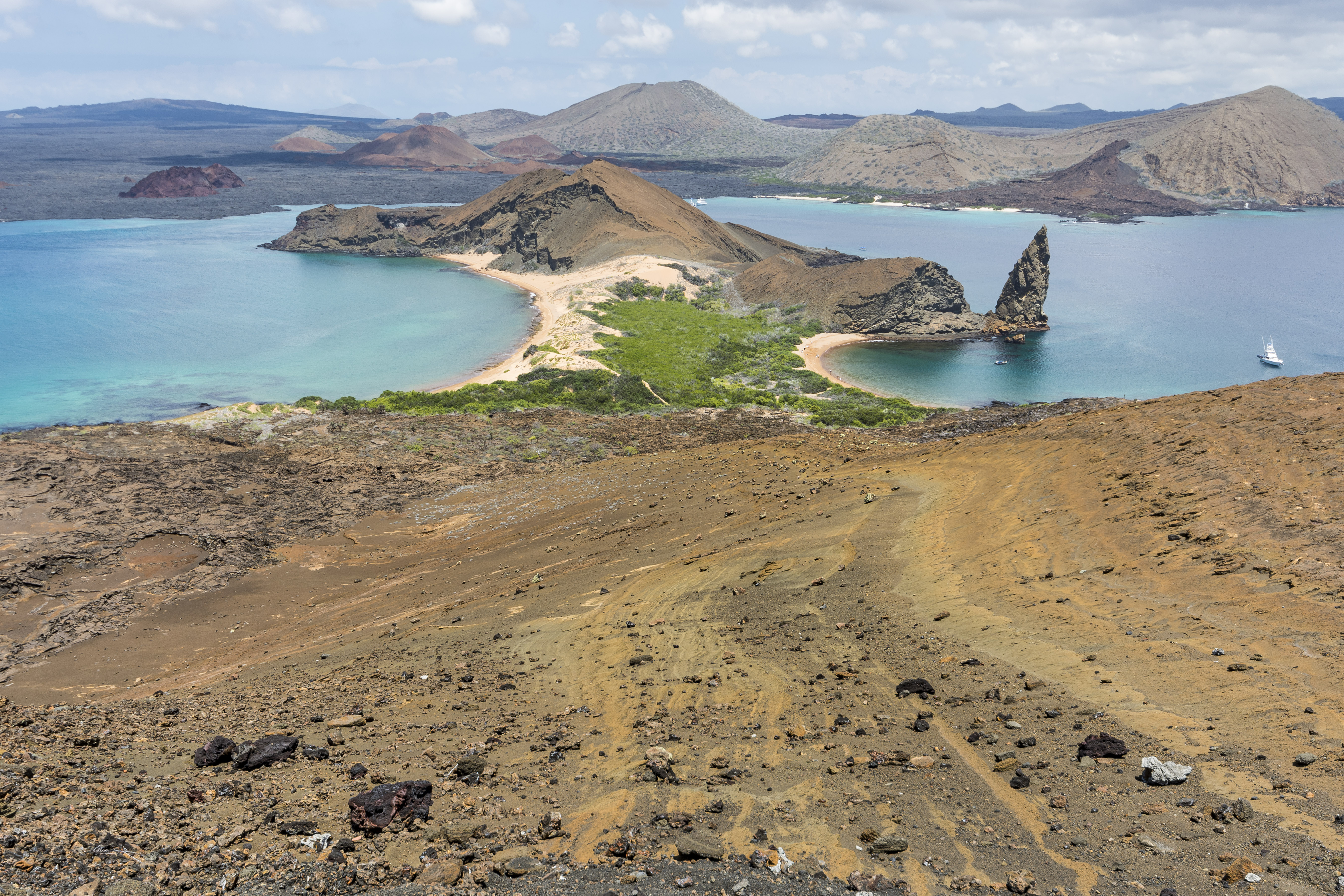
View the opening image ↑Pinnacle Rock and the bays of Bartolomé, in the Galápagos. Ecuador's most famous asset is 1,000 km offshore and now costs US$200 just to enter.
It is also, at the time of writing, the Andean country whose situation has changed most. Ecuador spent decades as the region's safe, easy, backpacker-friendly option. Between 2019 and 2023 the homicide rate rose roughly sevenfold, and 2025 set a new record as transnational cocaine trafficking took hold in the port cities, and in January 2024 the government declared an "internal armed conflict" after gunmen took over a live television broadcast. That is not a reason to cancel a trip. It is a reason to plan one differently from how you would have planned it in 2018, and the safety section on this page treats it properly rather than burying it.
Practically: the currency is the US dollar, which removes an entire category of travel friction. Quito sits at 2,850 m, which introduces another. The Andean corridor, the cloud forest and the Galápagos are the trip most visitors should take, and the coast — with the exception of a few specific places — is the part to think hardest about.
Two weeks is the sensible minimum for mainland plus Galápagos; ten days does the mainland well on its own. Ecuador rewards moving slowly more than most countries, because the distances are short and the altitude is not.
Ecuador is the only country in the world named after a line of latitude. The name was adopted at independence in 1830 and comes directly from the French Geodesic Mission of 1735–1744, which came here to measure an arc of the meridian at the equator and settle whether the Earth bulges at the middle or at the poles. It does bulge at the middle, Newton was right, and the expedition left the region with a name.
Full name
República del Ecuador. Independence from Spain effectively dates to the Battle of Pichincha on 24 May 1822; separation from Gran Colombia came in 1830.
Plurinational
The 2008 constitution defines Ecuador as a plurinational and intercultural state, recognising 14 indigenous nationalities and making Kichwa and Shuar official languages of intercultural relation alongside Spanish.
Rights of nature
The same constitution was the first in the world to grant enforceable legal rights to nature — Pachamama — as a subject rather than as property. Cases have been won under it.
Four worlds
Ecuadorians divide their country into four regions and identify strongly with them: the Costa, the Sierra, the Oriente (Amazon) and the Región Insular (Galápagos). Coastal and highland identities are genuinely different and cheerfully rivalrous.
Currency
The US dollar, adopted in 2000 after a banking collapse wiped out the sucre. Ecuador mints its own centavo coins, which circulate alongside American ones and are worthless outside the country.
The other equator country
Plenty of countries the equator crosses; only this one is named for it. The line runs about 25 km north of Quito, and the monument built to mark it is in slightly the wrong place.
03
Geography & the Four Regions
Two parallel Andean ranges run the length of the country, with a high valley between them that Alexander von Humboldt named the Avenue of the Volcanoes. West of the Andes the land drops to the Pacific plain; east of them it falls into the Amazon basin. And 1,000 km out in the Pacific sit the Galápagos. No other country packs those four environments into so small a space.
The Andean corridor: Quito, Cuenca, Riobamba, Otavalo, the volcanoes and the páramo. Between about 2,200 and 3,500 m for the inhabited parts, and cool all year.
La Costa
The Pacific lowland: Guayaquil, the banana and shrimp economy, the beaches, and Ecuador's largest city. Hot, humid and a completely different culture.
El Oriente
The Amazon, roughly half the country's territory and under 5% of its population. Oil, indigenous nations, and some of the highest biodiversity ever recorded.
Galápagos
13 major islands and over 100 islets, 1,000 km offshore, formed by a volcanic hotspot and still actively erupting. A separate province with its own rules and its own time zone.
Chimborazo
6,263 m, and because Earth bulges at the equator, its summit is the point on the planet's surface farthest from the centre of the Earth — about 2 km farther out than the summit of Everest.
Cotopaxi
5,897 m and one of the world's highest active volcanoes, 50 km from Quito. It reactivated in 2015 and again in 2022–23, closing the summit route for extended periods.
04
Map of Ecuador
Quito is in the northern highlands, Guayaquil on the southern coast, Cuenca in the southern Andes, and the Amazon begins about three hours east of Quito. The Galápagos are 1,000 km west and reached only by air.
110 km, about 2 hours. Easy day trip, better as an overnight.
Quito → Baños
185 km, 3–4 hours by bus. The classic first move south.
Quito → Cuenca
450 km, 9–10 hours by bus or 55 minutes by air. Fly it.
Quito → Tena / Coca
5–6 hours by road to the Amazon gateway towns; Coca is also served by air in 35 minutes.
Quito → Guayaquil
420 km, 8 hours by road or 50 minutes by air.
Galápagos
Flights from Quito (via Guayaquil) to Baltra (GPS) or San Cristóbal (SCY), about 2 hours from Guayaquil. There is no boat service for tourists.
Buses are the backbone of mainland travel: frequent, cheap — roughly US$1 to US$1.50 per hour of travel — and generally comfortable on the main routes. Internal flights are inexpensive and worth taking for the Quito–Cuenca and Quito–Coca legs.
05
History
Before the Inca there were the Quitu-Cara in the north, the Cañari around Cuenca and the Manteño on the coast, trading spondylus shell as far as Mexico. The Inca arrived late — the conquest of what is now Ecuador took most of the second half of the 15th century, and Cañari resistance was fierce enough that Huayna Cápac's campaigns are still remembered. Inca rule lasted barely fifty years before the Spanish.
Atahualpa, the last Inca emperor, was born in Ecuador and ruled the northern half of the empire from Quito. His civil war against his half-brother Huáscar had just ended when Pizarro landed in 1532. Quito was burned by the Inca general Rumiñahui rather than surrendered, and refounded by the Spanish in 1534.
Colonial Quito became a wealthy centre of religious art — the Quito School, whose polychrome sculpture and gilded carving fill the churches of the old town and is the finest colonial art tradition in South America. Independence came with the Battle of Pichincha on the slopes above the city on 24 May 1822. Ecuador was part of Gran Colombia until 1830, when it left and took its name.
The twentieth century was dominated by the cacao and banana booms, a disastrous 1941 war with Peru that cost Ecuador a vast Amazonian territory, and after 1972 by oil — which built roads and hospitals and also opened the Amazon to colonisation and left Texaco's contamination in the northern Oriente, the subject of one of the longest environmental lawsuits in history.
Modern politics has been turbulent: three presidents removed between 1997 and 2005, ten years of Rafael Correa (2007–2017) and the 2008 constitution, then a sharp reversal, the 1999 banking collapse and dollarisation, mass Venezuelan immigration after 2017, and since 2021 the security crisis that now defines the country's politics.
The crisis produced the politics of the present. Presidential candidate Fernando Villavicencio was shot dead leaving a Quito rally on 9 August 2023, eleven days before the vote; Daniel Noboa, a 35-year-old banana heir, won the run-off that October and became the youngest president in the country's history. In January 2024, after the gang boss "Fito" Macías walked out of a Guayaquil prison and gunmen stormed TC Televisión's live broadcast, Noboa declared an "internal armed conflict"; in April 2024 police raided the Mexican embassy in Quito to seize former vice-president Jorge Glas, and Mexico broke off relations. A 61-year drought then shut off the hydro dams and gave the country up to 14 hours a day of blackouts from September to 20 December 2024.
Noboa was re-elected on 13 April 2025 with 55.6% against Luisa González. Fito was recaptured in a bunker under a house in Manta on 25 June 2025 and extradited to New York on 20 July — the first Ecuadorian ever sent to the United States for trial. A 31-day CONAIE national strike over the abolition of the diesel subsidy (22 September–22 October 2025) left three dead and ended without its demands met, and on 16 November 2025 voters rejected all four of Noboa's referendum questions, including the return of foreign military bases and a constituent assembly. 2025 closed as the deadliest year on record, 9,216 homicides. As this page is updated, Executive Decree 498 of 15 September 2026 — roughly the twentieth state of exception since January 2024 — has put eight provinces under emergency rule for 60 days, with a midnight-to-5 a.m. curfew in Guayas, Manabí, Los Ríos and El Oro until 30 September.
06
The Indigenous Nations
Ecuador recognises 14 indigenous nationalities and 18 peoples, and unlike in many of its neighbours they are a decisive political force rather than a cultural footnote. CONAIE, the national indigenous confederation founded in 1986, has brought down governments — the uprisings of 1990, 2000, 2019 and 2022 each reshaped national politics, and the 2019 and 2022 strikes shut the country down for weeks. The 31-day strike of September–October 2025 against the end of the diesel subsidy was the first to end without a government concession, at a cost of three lives and 15 charges of terrorism against protesters.
By far the largest group, in the highlands and in the Amazon, speaking the northern variety of Quechua. Otavalo, Salasaca, Saraguro, Cañari and Puruhá are distinct Kichwa peoples with their own dress and history.
Shuar & Achuar
Southern Amazon. The Shuar were never conquered by the Inca or the Spanish, and several Achuar communities run their own lodges and airstrips on strictly community-controlled terms.
Waorani
Contacted only in the 1950s, in and around Yasuní. Their territory sits on top of the oil, which is the central conflict of the Ecuadorian Amazon.
Tagaeri & Taromenane
Waorani-related groups living in voluntary isolation inside the Yasuní Intangible Zone. Their existence is legally protected and their protection is the strongest argument against drilling there.
Tsáchila & Chachi
Coastal lowland peoples west of the Andes. Tsáchila men's red-dyed hair, using achiote, is the best-known image, though it is now largely ceremonial.
Visiting well
Community tourism is well developed and genuinely community-owned in many places. Book through the community's own operator, ask before photographing anyone, and treat a village as a village.
07
Quito
Quito sits in a narrow valley at 2,850 m on the flank of the Pichincha volcano, which makes it the second-highest capital in the world after La Paz and the reason most visitors spend their first day moving slowly. Its Centro Histórico is the largest and best-preserved colonial centre in the Americas, and in 1978 it was on the founding World Heritage List of twelve sites alongside Kraków, Aachen and Yellowstone — Quito is World Heritage property no. 2, the first city ever inscribed, with the Galápagos as no. 1.
Seven tonnes of gold leaf over Baroque carving, finished over 160 years. The most extravagant church interior in South America, and worth the ticket even for the entirely irreligious.
San Francisco
The oldest church and the largest colonial complex on the continent, begun weeks after the city was founded in 1534. The plaza in front is the best in Quito.
La Basílica del Voto Nacional
Neo-Gothic, unfinished by design, and with gargoyles shaped as Galápagos tortoises, iguanas and boobies. You can climb the towers on open steel walkways — vertigo sufferers, do not.
El Panecillo
The winged Virgin of Quito on the hill above the old town, 41 m of aluminium. Take a taxi up and down; the path is not safe.
TelefériQo
The cable car up Pichincha to about 4,000 m, with the Rucu Pichincha summit walk beyond. Do it after two days of acclimatisation, not on arrival.
La Ronda
The restored 17th-century lane of workshops, bars and canelazo stands. Lively, safe and the pleasantest evening in the old town.
Practical: stay in La Floresta or La Mariscal's quieter edges for restaurants and safety, or in a restored house in the Centro Histórico for atmosphere. Use registered taxis or apps rather than street cabs, and do not walk the old town after dark outside La Ronda.
08
The Equator — Mitad del Mundo
About 25 km north of Quito stands the Ciudad Mitad del Mundo, a 30 m monument with a yellow line painted down the plaza and a globe on top, built in 1979 to mark where the French Geodesic Mission determined the equator to be. GPS puts the actual line about 240 m to the north. The monument has not moved.
The monument
A pleasant complex with a good ethnographic museum inside the tower, a planetarium and restaurants. It is a genuine historic marker of an 18th-century scientific achievement, just not of the equator.
Museo Intiñán
The neighbouring private museum, which sits much closer to the true line and demonstrates water draining in opposite directions either side of it. That demonstration is a parlour trick — the Coriolis effect is far too weak to steer a sink — and the museum is fun anyway.
Standing on it
You can straddle the line at either place and it costs a few dollars. Nobody will mind that you know the monument is slightly off; the guides will tell you themselves.
The real achievement
La Condamine's expedition spent nine years here triangulating the meridian arc, in conditions that killed several members, to settle the shape of the Earth. That is what the monument commemorates.
Quitsato
A different and better sundial monument at Cayambe, on the actual line, built by an Ecuadorian research project and much less visited.
Practical
Half a day from Quito, easily combined with the Pululahua crater — a huge inhabited volcanic caldera ten minutes further on, and a better sight than the monument.
09
Cuenca
Cuenca, 2,550 m in the southern Andes, is the country's third city and the one visitors most often say they could live in — which a substantial North American retirement community has taken literally. Its historic centre, inscribed by UNESCO in 1999, is a grid of cobbled streets, red-tiled roofs, four rivers and an unusual density of good coffee.
Begun 1885, with sky-blue and white tiled domes and a facade of pink marble and brick. The towers were left short because the architect miscalculated and the foundations would not carry them.
Museo Pumapungo
Built over an Inca site at the edge of the centre, with a strong ethnographic collection including the shrunken heads (tsantsas) of the Shuar, displayed with proper context.
Panama hats
Cuenca is one of the two centres of the trade. The Museo del Sombrero and the working factories explain how a hat woven from toquilla straw came to be named after the wrong country.
El Barranco
The bluff above the Tomebamba river where the old city ends in a wall of balconied houses. The riverside walk below it is the nicest half-hour in Cuenca.
Cajas National Park
Forty minutes west: 270 lakes on the páramo at 3,000–4,400 m, with polylepis woodland and superb walking. Cold, wet and beautiful.
Ingapirca
Two hours north, the largest Inca site in Ecuador, built by the Cañari and taken over by the Inca. The elliptical Temple of the Sun is unlike anything in Peru.
10
Guayaquil & the Coast
Guayaquil is Ecuador's largest city and its economic engine — the port through which the bananas, shrimp and cacao leave and, unfortunately, through which the cocaine leaves too. It is hot, flat, energetic and, since 2021, the epicentre of the country's security crisis. Most visitors pass through its airport rather than the city, and under current conditions that is a defensible choice.
The regenerated riverfront along the Guayas — gardens, museums, a Ferris wheel, and controlled access. Genuinely pleasant and genuinely a bubble.
Las Peñas & Santa Ana
The painted hillside district and 444 steps to a lighthouse and a view. Fine by day with normal caution; not after dark.
Parque Seminario
The "iguana park" in the centre, full of land iguanas that have simply always lived there. Free, odd and charming.
Montañita
The coast's surf and party town. Cheap, fun, and with a real drug and assault problem that predates the wider crisis. Go with your eyes open or go to Ayampe or Olón instead.
Puerto López
The base for Isla de la Plata — the "poor man's Galápagos", with blue-footed boobies and a fraction of the cost — and for humpback whale watching from June to September.
Current advice
Guayaquil, Esmeraldas, Durán, Manta and Quevedo carry the highest risk in the country. Check your foreign ministry's current advice before planning coastal travel; see the safety section.
11
Otavalo & the Northern Highlands
The Otavalo market is the largest indigenous market in South America and it has been running, in some form, for at least six centuries — the Otavaleños were traders under the Inca and remain the most commercially successful indigenous group on the continent, with family businesses selling textiles from Bogotá to Barcelona.
The full market fills the Plaza de Ponchos and spills across the town. Go early — the animal market on the edge of town starts before dawn and is over by nine.
Other days
The Plaza de Ponchos trades daily and is perfectly good on a Wednesday, with a fraction of the crowd and slightly better prices.
Bargaining
Expected and good-humoured. Start around two-thirds and settle above half. Alpaca is often acrylic; genuine wool feels different and costs more.
Peguche & Iluman
Villages outside town where the weaving and the instrument-making actually happen. Workshops welcome visitors and the buying is better than in the plaza.
Cuicocha & Cotacachi
A crater lake with two islands at 3,100 m and a four-hour rim walk, plus the leather-goods town of Cotacachi below it.
Laguna de Mojanda & Fuya Fuya
Three lakes at 3,700 m with a 4,263 m peak above them — the standard acclimatisation hike before Cotopaxi or Cayambe.
12
Baños & the Waterfall Route
Baños de Agua Santa sits at 1,800 m in the gorge where the Andes fall away into the Amazon basin, under the active Tungurahua volcano. It is Ecuador's adventure capital: thermal baths, canyoning, rafting, bridge jumps, and a road east that passes a waterfall every few kilometres.
60 km east to Puyo past a dozen waterfalls, done by hired bicycle downhill (with a truck back), by chiva open bus, or by scooter. The classic Baños day.
Pailón del Diablo
The big one: a thundering fall with walkways cut into the rock that take you behind and under the water. You will get soaked. It is the best single sight in the central highlands.
Casa del Árbol
The tree-house swing over the gorge that made Baños Instagram-famous, with Tungurahua opposite on a clear morning. Safer than the photographs suggest.
Thermal baths
The town is named for them. Termas de la Virgen under the waterfall in the middle of town is the classic; go early or late to avoid the crush.
Tungurahua
Erupted more or less continuously from 1999 to 2016, with repeated evacuations of the town. Currently quiet; the ash-covered roofs and the evacuation signs are still there.
Into the Amazon
Baños is the natural gateway east — Puyo and Tena are two to three hours on, and the change in vegetation over that road is one of the best drives in South America.
13
The Galápagos
Nineteen volcanic islands and over a hundred islets, 1,000 km out in the Pacific, sitting on a hotspot and in the collision of three ocean currents — which is why an equatorial archipelago has penguins and fur seals alongside flamingos and tropical fish. In 1978 the Galápagos became one of the first sites ever inscribed on the World Heritage List.
Charles Darwin spent five weeks here in 1835 aboard HMS Beagle, and did not have his idea on the islands — he had it years later in London, once John Gould pointed out that the finches he had collected sloppily were separate species. The islands did not produce evolution by natural selection in a flash of insight. They produced the evidence that made it inescapable.
The animals
Giant tortoises, marine and land iguanas, blue-footed and Nazca boobies, waved albatross (Española, April–December), flightless cormorant, Galápagos penguin, sea lions everywhere, hammerheads and whale sharks at the northern islands.
They do not run
The defining experience is not rarity but indifference: nothing here evolved to fear a primate, so a sea lion will sleep on the jetty next to you. The 2 m rule exists because the animals will not keep the distance themselves.
Cruise vs land-based
A live-aboard cruise reaches the outer islands — Fernandina, Genovesa, Española, the northern dive sites — that day trips cannot. Land-based from Santa Cruz or San Cristóbal is far cheaper and still very good.
Santa Cruz
The main island: Puerto Ayora, the Charles Darwin Research Station, the tortoise reserve in the highlands, and Tortuga Bay, a 2.5 km white beach reached on foot.
Isabela
The biggest and least developed, with the Sierra Negra caldera walk, penguins at Las Tintoreras and the most relaxed town in the islands.
San Cristóbal
The provincial capital, an airport, Kicker Rock for diving and snorkelling, and a sea lion colony that has taken over the town's main beach.
The Galápagos is the most heavily regulated destination in the Americas and, since 1 August 2024, considerably more expensive: the national park entrance fee for foreign adults doubled from US$100 to US$200. Budget for it, and for everything else, before you decide.
The fees
Park entrance US$200 (foreign adult, cash on arrival), plus a US$20 transit control card (TCT) that since May 2025 is bought online before you fly, not at the airport desk. Children and residents of Andean Community countries pay less.
Getting there
Only by air, from Quito (usually via Guayaquil) to Baltra (GPS, for Santa Cruz) or San Cristóbal (SCY). Return fares are typically US$350–550. There is no ferry from the mainland.
Cruises
Four to fifteen nights, from around US$2,500 per person for a week on a modest boat to well over US$8,000. Last-minute deals booked in Puerto Ayora still exist but are far rarer than the guidebooks suggest.
Land-based
Hotels from US$40, day tours US$120–250, inter-island speedboats US$35 each way and genuinely rough. A week land-based can be done for US$1,200–1,800 all in, park fee included.
The rules
A licensed naturalist guide is required at almost all visitor sites; stay on the marked trails, keep 2 m from wildlife, no flash, no food, no touching, and nothing organic in or out. Biosecurity checks your bags at both ends.
Best time
December–May is warmer, calmer and better for snorkelling; June–November is cooler with rougher seas, stronger currents and the best diving and seabird activity. There is no bad month.
Seasickness
The crossings between islands are open Pacific in a small boat. If you are prone, this matters more than any other single comfort factor — take medication before boarding, not after.
Is it worth it?
For most people, once, yes — there is nowhere comparable. If the budget forces a choice, a well-run mainland trip with Isla de la Plata and the cloud forest delivers more per dollar and no shame.
15
The Amazon, Yasuní & the Rights of Nature
Ecuador's Oriente is roughly half the country and holds under 5% of its people. Yasuní National Park, where the Andes, the equator and the Amazon meet, has recorded biodiversity levels that are among the highest ever measured anywhere: more tree species in one hectare than in all of the United States and Canada combined, and over 100,000 insect species per hectare by one estimate.
It also sits on top of oil. In 2007 Ecuador offered the world a deal — leave the ITT block under Yasuní undrilled in exchange for half its value in compensation. The world contributed a fraction of the target and the initiative was abandoned in 2013. Then, in August 2023, Ecuadorians voted in a national referendum to halt extraction in Block 43-ITT and wind the wells down. It is the first time a country has voted to leave proven oil reserves in the ground, and the implementation is contested and ongoing.
Getting there
Coca (Francisco de Orellana) for the lower Napo and Yasuní — 35 minutes by air from Quito, then two to four hours by motorised canoe. Tena and Puyo are closer and cheaper but the forest is more disturbed.
Lodges
From basic community-run cabins at US$60 a night to serious research-grade lodges at US$300+. The expensive ones buy you a canopy tower, a good guide and distance from the oil roads — all three matter.
Community-owned
Several Kichwa, Achuar and Waorani communities own and run their own lodges outright. Booking one puts the money where it does the most good and the guiding is usually the best available.
What you see
Parrot and macaw clay licks at dawn, monkeys of half a dozen species, caiman by torchlight, giant otters in the oxbow lakes, hoatzin, and — if you are lucky and patient — very little else, because rainforest wildlife is hard.
The rights of nature
Ecuador's 2008 constitution made nature a rights-bearing subject. Courts have used it: in 2021 the Constitutional Court halted mining in Los Cedros cloud forest on those grounds. It is not decoration.
Uncontacted peoples
The Tagaeri and Taromenane live in voluntary isolation inside Yasuní. Their zone is legally off-limits and no tour goes there. Anyone offering contact is offering something illegal and lethal.
16
The Avenue of the Volcanoes
Humboldt named it in 1802 and the name stuck: a 300 km valley between the two Andean ranges with more than thirty volcanoes along it, eight of them over 5,000 m. Ecuador is the easiest country in the world in which to stand on a glacier on the equator, and the hardest in which to take that lightly.
Near-perfect cone, one of the world's highest active volcanoes, an hour from Quito. The summit climb is a guided overnight on glacier with crampons and rope — not technical, but a genuine mountaineering day. Access depends on current volcanic activity.
Chimborazo · 6,263 m
The highest point in Ecuador and the farthest point on Earth's surface from its centre. Harder and colder than Cotopaxi. The refuge at 4,800 m is reachable by car and the vicuña herds around it are worth the drive alone.
Cayambe · 5,790 m
The only glaciated peak the equator passes through, and the highest point on the equator anywhere on Earth.
Rucu Pichincha · 4,698 m
Straight up from Quito's cable car, no technical skill needed, four hours return. The standard acclimatisation walk and a serious altitude test.
Sangay & Reventador
Two of the world's most persistently active volcanoes, both erupting more or less continuously. Sangay National Park is a World Heritage site.
Altitude
Do not climb anything above 4,500 m in your first three days. Quito at 2,850 m is the acclimatisation, and Fuya Fuya or Rucu Pichincha the test. Guides on Cotopaxi and Chimborazo are compulsory and correctly so.
17
Cloud Forest & Birds
Ecuador has recorded over 1,600 bird species — around a sixth of the world's total, in a country the size of the UK — including more than 130 species of hummingbird. The reason is the west slope of the Andes: a wall of cloud forest dropping from 4,000 m to sea level, packing a dozen life zones into fifty horizontal kilometres.
One of the 130-plus hummingbird species recorded in Ecuador. A good feeder station in the cloud forest will show you fifteen in an afternoon.yakovlev.alexey · CC BY-SA 2.0 · Image credits
Mindo
Two hours from Quito at 1,250 m, and the easiest cloud forest in South America to reach. Hummingbird feeders, the cock-of-the-rock lek at dawn, butterfly farms, tubing and a chocolate factory.
Bellavista & Tandayapa
Higher lodges above Mindo, cooler and mistier, and the serious birding addresses on the north-west slope.
Chocó
The lowland forest further west — one of the most biodiverse and most threatened ecoregions on Earth, and where the endemics are.
Podocarpus & the south
Around Loja and Zamora, the wettest and least-visited birding region, with an entirely different species list.
Antisana & the páramo
An hour east of Quito: Andean condor, carunculated caracara, and the country's best chance of seeing a condor at close range.
Practical
A guide roughly triples what you see. Lodges provide them; independent guides can be hired in Mindo for around US$60 a day. Take a waterproof — it is called cloud forest for a reason.
Quilotoa is a caldera 3 km across at 3,900 m, filled with a lake whose colour runs from jade to deep turquoise depending on the light and the minerals. It is a two-hour drive from Latacunga and the single most photographed thing in the Ecuadorian highlands.
The full circuit is about 10 km and five to six hours at altitude, with big views and big wind. Most people walk an hour along the rim and turn back, which is fine.
Down to the lake
Half an hour down a sandy path and an hour or more back up. Mules are available at the bottom for around US$10 and are not a defeat.
The Quilotoa Loop
A three- to four-day village-to-village walk — Sigchos, Isinliví, Chugchilán, Quilotoa — through canyon and farmland, staying in family hostels. The best multi-day trek in Ecuador that does not need a guide.
Cotopaxi NP walks
Laguna Limpiopungo at 3,800 m, the refuge walk to 5,000 m, and the páramo with its wild horses. No mountaineering required.
El Cajas
Above Cuenca: 270 lakes, marked trails and genuinely alpine conditions. Weather changes in minutes; carry layers and do not go into the mist without a map.
Altitude again
Everything in this section is above 3,000 m and most of it above 3,800 m. Walk slowly, drink more than you want to, and do not schedule the loop for your second day in the country.
19
People & Culture
Eighteen million people, of whom roughly 70% identify as mestizo, 7–8% as indigenous, 7% as Afro-Ecuadorian and the rest as white or other. The country also absorbed something like half a million Venezuelans after 2017 — a large share for a country this size, and visible in every city.
Sierra vs Costa
The single most important cultural axis. Highlanders are seen as reserved, formal and indirect; coastal people as loud, warm and fast-talking. Both stereotypes are repeated affectionately by both sides.
Afro-Ecuadorians
Concentrated in Esmeraldas on the northern coast and in the Chota valley in the highlands — the latter a community descended from enslaved people brought to work Jesuit estates, and the source of the marimba tradition and a startling number of national footballers.
Formality
Greeting people properly matters. Buenos días on entering a shop, a handshake or a cheek kiss, and usted until invited otherwise. Skipping this reads as rudeness, not efficiency.
Family and Sunday
Sunday is family lunch, and in the highlands that often means a two-hour meal in a countryside restaurant. Businesses close; plan around it.
Punctuality
Flexible socially, strict for buses. The bus leaves when it says it leaves.
Religion
Predominantly Catholic with strong evangelical growth, and in the highlands a lived syncretism where the Catholic calendar sits on top of the Andean agricultural one — Inti Raymi and Corpus Christi are the same festival in most villages.
20
Language — Spanish & Kichwa
Highland Ecuadorian Spanish is the clearest in South America and a genuinely good place to learn: slow, fully pronounced, with none of the consonant-dropping of the Caribbean coast. Quito and Cuenca are full of language schools charging around US$8–12 an hour for one-to-one lessons, which is among the best value anywhere.
Kichwa
The Ecuadorian variety of Quechua, spoken by around a million people and an official language of intercultural relation. Ñuka shuti… — my name is… — and yupaychani — thank you — go a very long way in a highland village.
Coastal Spanish
Faster, with dropped final s, and much harder for learners. If you studied in Quito, Guayaquil will humble you for a day.
Chévere
Great, cool. The universal approval word.
¿Mande?
"Sorry, what?" — the standard polite request to repeat something. More common here than ¿qué?, which can sound blunt.
Achachay / arrarray
Kichwa loanwords that everyone uses: "how cold!" and "how hot!". Using them correctly gets a reaction.
English
Widespread in the Galápagos, in Quito's tourist areas and among guides; thin everywhere else. A hundred words of Spanish transforms this trip.
21
Food & Drink
Ecuadorian cooking divides on the same axis as everything else: the highlands eat potatoes, pork, corn and soup; the coast eats fish, shrimp, plantain, peanut and coconut. The best food in the country is in the almuerzo — the two- or three-course set lunch that costs US$3 to US$5 and is what everybody actually eats.
Encebollado
The national dish and the national hangover cure · 45 minutes · serves 4
Ingredients: Fresh albacore tuna, yuca (cassava), red onion, tomato, cilantro, cumin, lime, chilli. To serve: pickled onion, plantain chips, popcorn.
Method: Simmer the tuna with tomato, onion, cumin and cilantro until it flakes. Boil the yuca separately until soft and add it in chunks. Serve very hot in a deep bowl, topped with lime-and-onion curtido, with chifles and popcorn on the side to add as you go.
💡 It is eaten on Saturday and Sunday mornings, and the popcorn is not a garnish — you put it in the soup.
Llapingachos
Highland potato cakes · 40 minutes · serves 4
Ingredients: Floury potatoes, fresh cheese, achiote (annatto) oil, onion. To serve: chorizo or fried egg, avocado, peanut sauce, pickled onion.
Method: Mash the boiled potatoes with sautéed onion and achiote oil. Form patties around a core of cheese and fry on a griddle until crusted on both sides. Serve with peanut sauce, avocado, a fried egg and salad.
💡 The achiote is what makes them orange and is not optional. Ambato and Latacunga each claim the best version.
Ceviche
Ecuadorian ceviche is a different dish from the Peruvian one: shrimp, cooked, served in a cold tomato-and-lime broth you can drink, with popcorn and chifles. Do not compare them out loud in Peru.
Hornado & fritada
Whole roast pork and slow-fried pork, both served with hominy, potato cake and pickled onion. Market food, and best from a stall with a queue.
Cuy
Roast guinea pig, an Andean staple for thousands of years, served whole. Genuinely traditional and genuinely an acquired texture.
Locro de papa
Potato and cheese soup with avocado — the comfort food of the highlands and the best thing to eat on your first cold night in Quito.
Canelazo
Hot aguardiente with cinnamon, sugar and naranjilla juice. The highland answer to being at 2,850 m after dark, and the drink to order in La Ronda.
Chocolate & coffee
Ecuador grows around 60% of the world's fine-aroma Nacional cacao. Buy bean-to-bar chocolate at a shop, not the airport, and drink the highland coffee while you can.
The Panama hat is made in Ecuador, has always been made in Ecuador, and is called a Panama hat because that is where nineteenth-century buyers picked it up. Theodore Roosevelt wore one while visiting the canal works in 1906, the photograph went everywhere, and a national craft acquired another country's name permanently. UNESCO inscribed the weaving of the sombrero de paja toquilla on the Intangible Cultural Heritage list in 2012.
The material
Carludovica palmata, the toquilla palm, grown on the coast around Montecristi and Jipijapa. The stems are split, boiled and dried before weaving.
Montecristi
The town that makes the finest hats in the world. A superfino takes a skilled weaver months, is woven only in the humid hours before dawn, and sells for thousands of dollars.
Cuenca
The commercial centre, producing the great majority of hats at every quality level. Factories welcome visitors and explain the grading properly.
Grading
Counted in weaves per inch. A tourist hat has perhaps 100–200 weaves; a Montecristi superfino can exceed 2,000 and holds water. Anything under about US$30 is a machine-finished souvenir, which is fine if you know it.
Buying
Cuenca or Montecristi, from a shop that will let you look through the crown at the light — a good hat shows an even, tight, concentric weave with no gaps.
Carrying it
A genuinely fine hat rolls and travels in a balsa box. A cheap one does not — roll it and you will crack the straw.
23
Festivals
Inti Raymi · June
The Andean solstice festival, strongest around Otavalo and Cotacachi, where it merges with the Catholic feast of San Juan. Days of dancing in circles, masked aya uma figures, and a ritual taking of the church plaza that is not always symbolic.
Carnaval · February
Water. Everywhere, at everyone, for three days, with foam spray added. Ambato holds the Fiesta de las Flores y las Frutas instead, which is the country's largest parade and mercifully dry.
Diablada de Píllaro · 1–6 January
Thousands of masked devils dancing through a small highland town for six days. Spectacular, loud, and much less visited by foreigners than it deserves.
Día de los Difuntos · 2 November
All Souls, with families spending the day in the cemetery, and colada morada — hot spiced purple berry drink — with guaguas de pan, bread babies. The best food week of the year.
Fiestas de Quito · early December
The capital's founding week: bullfight-free now, but with parades, open-air concerts and open-top chiva buses touring the city with a brass band aboard.
Mama Negra · November
Latacunga's extraordinary syncretic parade — a man dressed as a black woman on horseback, surrounded by dancers, in a festival that fuses indigenous, African and Spanish elements and defies summary.
24
Ecuador on Screen & Page
The Voyage of the Beagle
Darwin's own account. The Galápagos chapter is short, and reading it on the islands is a genuinely different experience from reading it at home.
Huasipungo (1934)
Jorge Icaza's brutal novel of indigenous serfdom on a highland estate — one of the founding texts of Latin American indigenist literature and still shocking.
Savages / Crude
Joe Kane's book and Joe Berlinger's 2009 documentary on the Waorani, Texaco and the oil lawsuit. The essential background to the Amazon section of this page.
The Galápagos Affair (2013)
A documentary about the German settlers, a self-styled baroness and the unexplained deaths on Floreana in the 1930s. True, strange and perfect pre-trip viewing.
Ratas, ratones, rateros (1999)
Sebastián Cordero's film, the beginning of modern Ecuadorian cinema and a hard look at Guayaquil and Quito's margins.
Music
Pasillo is the national song form — slow, sung, melancholy, on UNESCO's intangible heritage list since 2021 — and Julio Jaramillo its greatest voice. On the coast, listen for marimba esmeraldeña, a UNESCO-listed Afro-Ecuadorian tradition since 2015.
25
Climate & When to Go
On the equator, so there are no seasons in the temperate sense — altitude decides the temperature and the rain decides the calendar. Quito at 2,850 m sits at 10–20 °C every single month of the year. Guayaquil at sea level sits at 25–33 °C every month. What changes is how wet it is.
Sierra · Jun–Sep
The dry season in the highlands: clearest mountain views, best climbing conditions, and the busiest and priciest months. December and January are a shorter second dry spell.
Sierra · Oct–May
The wet season, which in practice means sunny mornings and afternoon rain rather than all-day downpour. Green, cheap and perfectly travellable.
Costa · Dec–May
Hot, humid, sunny between showers, and the beach season. June to November is cooler, grey and misty — the garúa — with much less rain.
Amazon
Rains all year. The heaviest months are roughly April to July; the drier spell around December to February means lower rivers and better walking.
Galápagos · Dec–May
Warm, calm sea, better snorkelling and visibility, brief heavy showers. June–Nov is cooler with rough seas, stronger currents, richer plankton and the best diving.
Overall best
June to September if you are focused on the mountains; December to April if the coast or Galápagos snorkelling matters most. Whale watching off Puerto López runs June to September.
26
Getting There & Getting Around
Two international airports: Quito (UIO), which is 45 minutes east of the city on a good toll road, and Guayaquil (GYE), which is fifteen minutes from its centre. Quito is the right arrival for the Andes, the Amazon and most Galápagos itineraries.
Airlines
Iberia and Air Europa from Madrid, KLM from Amsterdam, LATAM and Avianca via Bogotá, Lima or São Paulo, plus American, Delta, United and Copa from North America and Panama.
Quito airport
At 2,400 m — lower than the city, which surprises people. Take a registered airport taxi or a pre-booked transfer; expect US$26–35 into town and 45–60 minutes.
Buses
Excellent, frequent and about US$1–1.50 per hour of travel. Use the main terminals (Quitumbe and Carcelén in Quito) and the larger companies; keep bags on your lap or between your feet, never overhead or underneath unchecked.
Internal flights
Cheap and worth it for Quito–Cuenca, Quito–Coca and anything to the Galápagos. LATAM, Avianca and Aeroregional operate domestically; Equair, the third carrier, folded on 30 September 2023, so ignore any fare you find quoted for it.
Taxis and apps
Uber, Cabify and InDrive work in Quito, Guayaquil and Cuenca and are much safer than hailing on the street. Insist on the meter in a street taxi, or agree the fare first.
The train
Ecuador's tourist railway was liquidated in 2020, but the famous Devil's Nose (Nariz del Diablo) switchback, Alausí–Sibambe, came back in 2025 under municipal management and, after a February 2026 landslide, has run again since 6 June 2026: Thursday to Sunday at 08:00, 11:00 and 14:00, about 2½ hours round trip, US$30 for foreigners. TIME named it one of the World's Greatest Places of 2026. The rest of the old network remains closed.
27
Getting There from Europe & Czechia
There is no direct flight from Central Europe, but Ecuador is well served from Madrid and Amsterdam, which makes it one of the easier South American countries to reach from Prague.
Via Madrid
Iberia and Air Europa fly Madrid–Quito and Madrid–Guayaquil daily, around 11 hours. Usually the cheapest and simplest routing from Prague, on one ticket.
Via Amsterdam
KLM flies Amsterdam–Quito–Guayaquil, connecting well from Prague and often with better schedules than Madrid.
Via Bogotá or Panama
Avianca and Copa connect from several European gateways. More stops, sometimes cheaper, and worth checking if you plan to combine Ecuador with Colombia.
From Prague
Reckon on 16–20 hours with one or two connections. Return fares typically CZK 22,000–38,000 depending on season and how far ahead you book.
Arriving at altitude
You will land at Quito after roughly twenty hours awake and go straight to 2,850 m. Do nothing on day one, drink water, skip the alcohol, and postpone anything ambitious to day three.
Combining
Ecuador pairs naturally with Colombia (bus or short flight) and with Peru (bus from Loja or Huaquillas, or a flight to Lima). The land border crossings are functional but slow.
28
Safety — an Honest Assessment
This section exists because most guidance about Ecuador was written before 2021 and is now wrong. Between 2019 and 2023 Ecuador's homicide rate rose from under 7 per 100,000 to about 47, and 2025 was worse still — 9,216 killings, roughly 50 per 100,000, the highest ever recorded here — among the highest in Latin America — as Mexican and Balkan trafficking networks took over the cocaine route through its Pacific ports. In January 2024 the government declared an "internal armed conflict" against the gangs after armed men seized a live television studio in Guayaquil.
What this means for a visitor is narrower than the headlines suggest. The violence is overwhelmingly concentrated in specific places — the port cities and the northern border — and overwhelmingly between and within criminal organisations and the prison system. Tourists are not targets. But the environment has changed and the old "safest country in the Andes" advice should be discarded.
Highest risk
Guayaquil, Durán, Esmeraldas province, Manta, Quevedo, and the northern border with Colombia (Sucumbíos, Carchi). Some of these carry "do not travel" advisories from several European foreign ministries.
Lower risk
The Galápagos, Cuenca, Loja, Baños, Otavalo, Mindo, the Cotopaxi corridor and the Amazon lodges are all far less affected and are where most tourism happens. Quito is in between: fine with normal urban care, with real robbery risk in specific areas.
Express kidnapping
The specific crime to know about: a short abduction, usually from an unlicensed taxi, to empty your bank cards at ATMs. The defence is simple — never hail a street taxi, always use an app or a hotel-booked car.
Robbery
Bag snatching, phone theft and occasional armed robbery in Quito's Mariscal, the old town after dark, and around bus terminals. Carry a decoy amount of cash, keep your phone out of sight, and do not resist.
Buses
Overnight intercity buses have a long-standing theft problem. Travel by day on the main routes, keep valuables on your body, and use the larger companies from the official terminals.
State of emergency
Emergency decrees and curfews have been imposed roughly twenty times since January 2024, at short notice and regionally. The current one, Decree 498 of 15 September 2026, covers eight provinces for 60 days, with a midnight–05:00 curfew in Guayas, Manabí, Los Ríos and El Oro from 17 to 30 September 2026 — no transit permits, and warrantless searches are lawful inside the zone. They affect nightlife and movement more than daytime travel. Check the news before you fly and after you land.
Official advisories · September 2026
The US State Department (18 August 2026) keeps Ecuador at Level 2 overall, says reconsider travel to Manabí, Santa Elena, Santo Domingo and Sucumbíos, and marks Do Not Travel zones: parts of Guayaquil, Huaquillas and Arenillas in El Oro, Quevedo, Quinsaloma and Pueblo Viejo in Los Ríos, and Esmeraldas city and everything north of it to the Colombian border. The UK, Germany and Czechia draw similar maps. Quito, Cuenca, the Sierra, the Oriente lodges and the Galápagos sit outside every no-go zone.
What to actually do
Read your own foreign ministry's current advice — it is updated far more often than any guidebook. Register your trip with your ministry's traveller system. Take insurance that covers a change of plan. Then go: the Andes, the cloud forest and the Galápagos remain excellent and are still visited by hundreds of thousands of people a year.
The honest bottom line
Ecuador in 2026 is a country where an ordinary well-planned trip to the Sierra, the Oriente and the islands is very unlikely to go wrong, and where a casual, improvised trip through the coastal cities is a meaningfully worse bet than it was ten years ago.
29
Practical Information
Visa
EU, UK, US, Canadian and most Latin American citizens enter visa-free for up to 90 days per calendar year. Ecuador's law requires visitors to hold health insurance valid for the stay; enforcement is inconsistent but have a policy.
Money
The US dollar is the currency. Bring clean, undamaged notes — torn or heavily marked dollars are refused. Ecuador mints its own centavo coins, which look odd and are valueless abroad.
Small change
The single most useful practical tip: breaking a US$20 is genuinely difficult outside cities. Carry ones, fives and coins; taxis, buses and markets will not have change.
Cards and ATMs
Cards work in hotels, better restaurants and supermarkets. ATMs are everywhere in towns; use ones inside banks or malls in daylight, and be alert leaving one.
Altitude
Quito 2,850 m, Cuenca 2,550 m, Quilotoa 3,900 m. Symptoms — headache, breathlessness, poor sleep — are normal on arrival. Go slowly for 48 hours, drink water, avoid alcohol on day one. Coca tea helps mildly; soroche tablets from any pharmacy help more.
Health
Yellow fever vaccination is recommended for the Amazon and required if arriving from some countries. Malaria risk is low but present in the lowlands. Do not drink the tap water; bottled or filtered everywhere.
Electricity
120 V, 60 Hz, US-style type A/B sockets. European appliances need an adaptor and a converter unless dual-voltage.
Connectivity
Claro and Movistar cover the country well; eSIMs work. Coverage is good in the Sierra and patchy in the Oriente.
Time zones
Mainland UTC−5, Galápagos UTC−6. No daylight saving. Check which one your Galápagos flight is quoted in.
Emergency
911 nationally. Tourist police operate in Quito, Cuenca and Guayaquil.
Sun
You are on the equator at altitude. The UV index in Quito regularly exceeds 11. Sunscreen, hat and sunglasses every day, including cloudy ones.
Tipping
10% is often added to restaurant bills; check before adding more. Guides on multi-day trips and Galápagos crews are tipped and it is a meaningful part of their income.
30
Costs
Mainland Ecuador is one of the best-value countries in South America; the Galápagos is one of the most expensive places in the hemisphere. Budget them separately or the average will mislead you badly. Figures are per person per day in US dollars — which is also the local currency, so what you read is what you pay.
Mainland budget · US$30–45
Hostel or basic hotel, almuerzo set lunches, buses, occasional entrance fees. Comfortable and entirely normal.
Mainland mid-range · US$70–120
Good hotel or a restored colonial guesthouse, restaurant dinners, some internal flights, a guided day or two.
Amazon lodge
US$120–400 per person per night all-inclusive, usually with a three- or four-night minimum, including the canoe transfer from Coca.
Galápagos land-based
US$150–250 a day including day tours, plus the US$200 park fee and US$20 transit card, plus US$350–550 for the flight.
Galápagos cruise
US$350–1,200 per person per night depending on the boat, plus fees and flights. A week rarely comes in under US$3,000 all in.
Typical prices
Almuerzo US$3–5 · restaurant main US$8–15 · bus per hour US$1–1.50 · Quito–Cuenca flight US$60–110 · Spanish lesson US$8–12/hour · Cotopaxi guided summit US$220–280.
31
Where to Stay
Quito
La Floresta for restaurants, cafés and a residential feel; the Centro Histórico for restored colonial houses and atmosphere; González Suárez for comfort and views. Avoid basing yourself in the heart of La Mariscal after dark.
Cuenca
The historic centre, almost without exception. Several beautiful conversions of 19th-century houses at prices that would buy a hostel bed in Europe.
Haciendas
The Sierra's distinctive accommodation: working colonial estates converted to hotels, with fireplaces, horses and enormous breakfasts. Hacienda country runs from Otavalo down past Cotopaxi and is worth building a trip around.
Amazon lodges
Booked as packages including transfers, guiding and all meals. Community-owned options cost less and often guide better.
Galápagos
Puerto Ayora (Santa Cruz) has the widest choice; Puerto Villamil (Isabela) is quieter and nicer; Puerto Baquerizo Moreno (San Cristóbal) is the easiest to fly into.
Booking
Book the Galápagos and the haciendas ahead; everything else can be arranged a day or two out except in the June–August and December–January peaks.
32
UNESCO World Heritage
Five inscriptions, and two of them were on the very first World Heritage List ever published in 1978 — the Galápagos and the city of Quito, alongside Kraków, Aachen and a handful of others.
Galápagos Islands · 1978
Natural, one of the first twelve sites ever inscribed. Extended in 2001 to include the marine reserve, which was itself expanded in 2022 by a further 60,000 km² as the Hermandad Reserve.
City of Quito · 1978
Cultural, property no. 2 on the list — the first city ever inscribed, on the founding list of twelve. Cited as the best-preserved and least-altered historic centre in Latin America.
Sangay National Park · 1983
Natural: two active volcanoes and an intact gradient from glacier to rainforest. On the Danger List through the 1990s because of a road; removed in 2005.
Historic Centre of Cuenca · 1999
Cultural, cited as an exceptionally well-realised example of a planned Spanish colonial inland town.
Qhapaq Ñan · 2014
The Andean road system, a transnational inscription shared with five other countries. Ingapirca and the Camino del Inca to it are the Ecuadorian components.
Intangible heritage
Four elements: the oral heritage of the Zápara people (2008, shared with Peru), toquilla straw hat weaving (2012), marimba music and chants of the Colombia–Ecuador Pacific region (2015, shared with Colombia) and pasillo, song and poetry (2021).
Tentative List · 15 sites
Ten were added in 2026 alone, including a Galápagos extension, the Ecuadorian Cacao Cultural Landscape, the Andean Chocó cloud forest, the Chimborazo reserve and the Churute mangroves; the older entries are Machalilla, the Puyango petrified forest, Zaruma, the Trans-Andean railway and Mayo Chinchipe. Nothing new for Ecuador at the 2025 or 2026 Committee sessions.
33
Fascinating Facts
Named after a latitude
Ecuador is the only country in the world named for a line of latitude, and it got the name from an 18th-century French scientific expedition.
The farthest point from Earth's centre
Chimborazo's summit, at 6,263 m, is about 2 km farther from the centre of the Earth than Everest's, because the planet bulges at the equator. It is the closest solid ground to the Moon.
It uses the US dollar
Ecuador abandoned its own currency in 2000 after a banking collapse, and mints only its own centavo coins. There is no Ecuadorian central bank monetary policy as a result.
Nature has legal rights
The 2008 constitution was the first in the world to make nature a rights-bearing subject. In 2021 the Constitutional Court used it to stop mining in the Los Cedros cloud forest.
A country voted oil into the ground
In August 2023 Ecuadorians voted by referendum to halt oil extraction in Yasuní's Block 43-ITT — the first national vote anywhere to leave proven reserves unextracted.
The Panama hat
Made in Ecuador, always has been. The finest are woven in Montecristi before dawn, when the humidity keeps the straw pliable, and can take six months.
1,600 bird species
Roughly one in six of all bird species on Earth, in a country the size of the UK, including over 130 hummingbirds. Only Colombia and Peru have more, and both are far bigger.
The monument is in the wrong place
Mitad del Mundo, built to mark the equator, stands about 240 m south of the actual line as measured by GPS. Nobody has proposed moving it.
The Galápagos has its own time
One hour behind the mainland, which catches out a predictable number of people with flights to catch.
34
Notable Ecuadorians
Atahualpa (c. 1502–1533)
The last Inca emperor, born in Ecuador and ruling the north from Quito. Captured at Cajamarca, filled a room with gold for a ransom that was taken, and was executed anyway.
Eugenio Espejo (1747–1795)
Physician, satirist and journalist of indigenous and Afro-Ecuadorian parentage, who wrote about disease transmission decades before germ theory and died in prison for his politics. The intellectual founder of Ecuadorian independence.
Manuela Sáenz (1797–1856)
Revolutionary, intelligence officer and Bolívar's partner, who saved his life in 1828 and died in poverty in Peru. Repatriated symbolically in 2010 and now a national figure in her own right.
Oswaldo Guayasamín (1919–1999)
The country's greatest painter — enormous, angular canvases about violence, poverty and indigenous suffering. His Capilla del Hombre in Quito is the single best museum visit in Ecuador.
Jorge Icaza (1906–1978)
Novelist, author of Huasipungo, the book that forced the country to look at how its indigenous population lived.
Julio Jaramillo (1935–1978)
"El Ruiseñor de América" — the voice of the pasillo, and still played in every taxi in Guayaquil.
Jefferson Pérez (b. 1974)
Race walker from Cuenca, Olympic champion in 1996 and Ecuador's first Olympic gold medallist — the only one until Carapaz in 2021 and Pintado in 2024. A genuine national hero.
Richard Carapaz (b. 1993)
Cyclist from Carchi, winner of the 2019 Giro d'Italia, Olympic road race champion in Tokyo, and in July 2026 winner of two Tour de France stages — including Alpe d'Huez — plus the polka-dot jersey for a second time. The reason a generation of Ecuadorian children now own bicycles.
Nemonte Nenquimo (b. 1985)
Waorani leader who led the 2019 legal case that protected half a million acres of Amazon from oil auction. Named to the TIME 100 in 2020.
35
Sports
Football first, then everything else. The current national side is called the golden generation for a reason: only Argentina finished above Ecuador in South American qualifying for the 2026 World Cup, Moisés Caicedo of Chelsea is among the best midfielders in the world, and Willian Pacho became the first Ecuadorian to lift the Champions League, with Paris Saint-Germain on 31 May 2025.
World Cup 2026
Drawn in Group E with Germany, Ivory Coast and Curaçao. A Gonzalo Plata goal in the 78th minute beat Germany 2–1 in Philadelphia on 25 June 2026, enough to go through as one of the best third-placed teams; Mexico then won 2–0 at the Azteca on 30 June (Quiñones, Jiménez) in the round of 32. Caicedo took the captaincy from the 36-year-old Enner Valencia, the country's all-time scorer, during the tournament.
Paris 2024 · five medals
The best Games in Ecuador's history: Daniel Pintado won the 20 km walk on 1 August 2024, the country's first athletics gold, then took silver with Glenda Morejón in the mixed relay — the first Ecuadorian with two medals at one Games. Lucía Yépez's silver in the 53 kg freestyle was Ecuador's first wrestling medal, with two bronzes besides.
Richard Carapaz
Skipped the 2026 Giro after surgery, then won stages 18 and 20 of the 2026 Tour de France — the second finishing on Alpe d'Huez — took the mountains classification for the second time and the super-combativity award, and rode to fourth overall at the Vuelta. He remains the only Ecuadorian with stage wins in all three Grand Tours.
Clubs
LDU Quito won the Copa Sudamericana in 2023, adding to Independiente del Valle's titles of 2019 and 2022; Barcelona SC and Emelec share Guayaquil and the country's fiercest derby, the Clásico del Astillero. The domestic league is the LigaPro; the Supercopa Ecuador was played in Quito on 13 May 2026.
Everything at altitude
Quito's stadium sits at 2,850 m, which is why visiting teams complain and why Ecuador's walkers, climbers and cyclists come from the Sierra. Jefferson Pérez, Olympic champion in 1996, is still the country's reference point; Cuenca named its athletics track after him.
Watching it
LigaPro tickets cost US$5–20; the Estadio Rodrigo Paz Delgado (Casa Blanca) in Quito is the safe, family-friendly ground. Ecuavisa and Teleamazonas carry the national team. Go early, sit in the general stands, and leave with the crowd.
36
Media & Press Freedom
Ecuador fell 31 places to 125th of 180 in the 2026 Reporters Without Borders index (score 44.37, from 94th in 2025) — the sharpest fall in the Americas. RSF cites the murders of journalists Darwin Baque and Patricio Aguilar in 2025, organised-crime pressure on newsrooms in Guayaquil and Esmeraldas, 55 attacks on reporters during the September–October 2025 strike, and increasingly hostile officials. The armed takeover of TC Televisión's live studio in January 2024 remains the image of the crisis.
Where to read
El Universo (Guayaquil) and El Comercio (Quito) are the papers of record; Primicias, GK and Plan V are the best independent sites; Ecuavisa and Teleamazonas lead in television. Correa's 2013 communications law, used to fine and sue the press, was largely dismantled in 2018–19.
For visitors
Expect to see armed guards outside newsrooms in Guayaquil. Foreign journalists are not targets; local reporters covering the ports are. If you are working, register with your embassy and follow Fundamedios, the press-freedom NGO that publishes weekly alerts.
Humboldt's name for the valley between the two Andean ranges, and it stuck.
Photographs are illustrative. Where an image could not be verified as a specific named place, the caption describes the subject in general terms rather than naming it.
38
Author's Note
Ecuador is the country I most often recommend to people who have never been to South America, and I have had to change how I recommend it. The case for going is unchanged and unusually strong: nowhere else lets you stand on a glacier at the equator on Tuesday and watch a sea lion ignore you on Friday, on a budget, in a country the size of the UK, using US dollars.
What has changed is that the improvised version of this trip — turn up, get on whatever bus, follow the coast, see where it goes — is no longer the good idea it was in 2015. Plan the route, stay in the Sierra and the islands, use apps rather than street taxis, read your foreign ministry's page the week you fly. That is not a heavy burden and it converts most of the risk back to normal.
The other thing worth saying: the Galápagos at US$200 entry plus flights plus a boat is now a serious financial decision, and it is fine to decide against it. Mindo and the Chocó will show you more species; Isla de la Plata will show you blue-footed boobies for a fortieth of the price; the Quilotoa Loop and a hacienda week will give you a better sense of the country than any cruise. Go to the islands if they are the reason you are coming. Do not go because you feel you have to.
I am updating this in the week a new state of exception put four coastal provinces under curfew. Nothing in it changes the advice above; it only confirms it.
—Radim Kaufmann, September 2026
Support This Project 🌍
This World Travel Factbook is a labor of love – free to use for all travelers. If you find it helpful, consider supporting its continued development.
.jpg)
_(29718399711).jpg)
